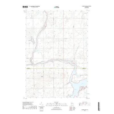
2018 Map of Flambeau Ridge
USGS Topo · Published 2018About this map
Flambeau Ridge rises prominently above the surrounding wetlands and river valleys at the convergence of three major waterways in Rusk and Chippewa counties. This 2018 survey documents the intricate hydrologic network where the Flambeau River and Chippewa River meet, flowing south toward the expansive Holcombe Flowage and the mouth of the Jump River. The landscape is defined by the sharp contrast between the elevated ridge and the low-lying glacial features like Pine Island and numerous kettles including Bollman Lake and LaRose Lake.
Find a feature on this map
58 named features on this map. Tap any name to fly to it.
Don’t see what you’re looking for? This feature index may not catch every label — zoom into the map to look around manually.
Map Details
Editions of this 2018 Flambeau Ridge Map
This is the sole edition of this map. No revisions or reprints were ever made.
Other maps of this area

1948 · Weyerhauser
USGS Topo · 1:48,000

1948 · Ladysmith
USGS Topo · 1:48,000

1949 · Bloomer
USGS Topo · 1:62,500

1950 · Weyerhauser
USGS Topo · 1:48,000

1950 · Ladysmith
USGS Topo · 1:48,000

1951 · Bloomer
USGS Topo · 1:62,500

1951 · Cornell
USGS Topo · 1:62,500

1953 · Rice Lake
USGS Topo · 1:250,000

1959 · Rice Lake
USGS Topo · 1:250,000
1971 · Ladysmith
USGS Topo · 1:24,000