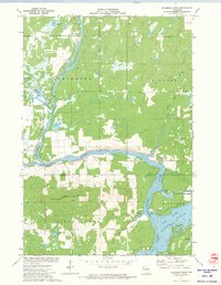
1971 Map of Flambeau Ridge
USGS Topo · Published 1974About this map
The Chippewa River and Flambeau River converge in this northern Wisconsin landscape, creating a complex hydrologic network defined by the Holcombe Flowage and numerous smaller bodies of water like Bollman Lake and La Rose Lake. The prominent landform of Flambeau Ridge rises south of the river junction, featuring the Flambeau Lookout Tower as a key landmark. The area is characterized by conservation and recreation, notably the Washington Creek State Wildlife Management Area and local community hubs such as St Francis Ch and the Townhall. Development around the flowage is evident through seasonal and residential features like North Shore Drive, the Sportsmen Club Park, and the Christian Harbor Youth Camp. This survey documents the intersection of industrial water management and public wilderness in Rusk and Chippewa counties during the early 1970s.
Find a feature on this map
30 named features on this map. Tap any name to fly to it.
Don’t see what you’re looking for? This feature index may not catch every label — zoom into the map to look around manually.
Map Details
Editions of this 1971 Flambeau Ridge Map
This is the sole edition of this map. No revisions or reprints were ever made.
Other maps of this area

1948 · Weyerhauser
USGS Topo · 1:48,000

1948 · Ladysmith
USGS Topo · 1:48,000

1949 · Bloomer
USGS Topo · 1:62,500

1950 · Weyerhauser
USGS Topo · 1:48,000

1950 · Ladysmith
USGS Topo · 1:48,000

1951 · Bloomer
USGS Topo · 1:62,500

1951 · Cornell
USGS Topo · 1:62,500

1953 · Rice Lake
USGS Topo · 1:250,000

1959 · Rice Lake
USGS Topo · 1:250,000
1971 · Ladysmith
USGS Topo · 1:24,000