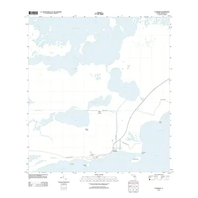
2012 Map of Flamingo
USGS Topo · Published 2012About this map
Everglades National Park covers this southern reach of Monroe County, where the Florida peninsula meets the shallow waters of Florida Bay. The settlement of Flamingo serves as the primary hub for land-based access to this coastal wilderness, featuring the Flamingo Campground and the southern terminus of Bear Lake Rd. The map reveals a complex network of waterways and early water management efforts, including the Homestead Canal and the Flamingo Canal, which cut through the sawgrass and mangroves near Roberts Prairie. Further inland, the vast expanse of Whitewater Bay dominates the northern landscape. Local landmarks such as the Bear Lake Mound and named points like Christian Point and Gibby Point provide orientation within this shifting landscape of keys, bays, and prairies. Foot travel is limited to established routes like the Coastal Prairie Trl and the Christian Point Trl, which wind through the coastal marshes.
Find a feature on this map
28 named features on this map. Tap any name to fly to it.
Don’t see what you’re looking for? This feature index may not catch every label — zoom into the map to look around manually.
Map Details
Editions of this 2012 Flamingo Map
This is the sole edition of this map. No revisions or reprints were ever made.
Other maps of this area

1956 · Miami
USGS Topo · 1:250,000

1958 · Miami
USGS Topo · 1:250,000

1972 · Whitewater Bay West
USGS Topo · 1:24,000

1972 · Whitewater Bay East
USGS Topo · 1:24,000

1972 · Mahogany Hammock
USGS Topo · 1:24,000

1972 · Lake Ingraham East
USGS Topo · 1:24,000

1972 · Pelican Keys
USGS Topo · 1:24,000

1972 · West Lake
USGS Topo · 1:24,000

1972 · Sandy Key
USGS Topo · 1:24,000

1972 · Clive Key
USGS Topo · 1:24,000