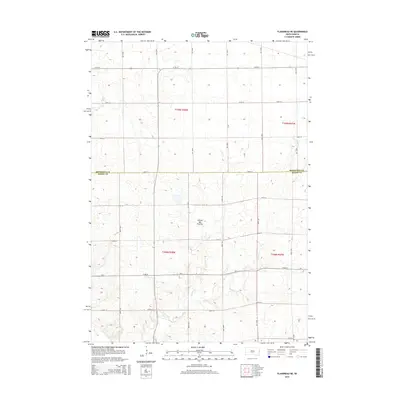
2015 Map of Flandreau NE
USGS Topo · Published 2015About this map
Coteau des Prairies, a vast glacial highland, dominates the topography of this eastern South Dakota landscape. Surveyed in 2015, the map documents a strictly organized agricultural grid along the boundary of Brookings and Moody Counties. The section lines are clearly defined by an extensive network of rural roads, including 220th St and 483rd Ave, which partition the land into productive townships like t109n r48w. Drainage for these prairie farmsteads is provided by Spring Cr, which meanders through the southern sections of the quadrangle. This detailed topographical record captures the modern infrastructure of the Great Plains, where county routes like Cr 4 and Cr 31 serve as the primary arteries for a dispersed rural population.
Find a feature on this map
25 named features on this map. Tap any name to fly to it.
Don’t see what you’re looking for? This feature index may not catch every label — zoom into the map to look around manually.
Map Details
Editions of this 2015 Flandreau NE Map
This is the sole edition of this map. No revisions or reprints were ever made.
Other maps of this area

1953 · Watertown
USGS Topo · 1:250,000

1958 · Watertown
USGS Topo · 1:250,000

1964 · Flandreau SW
USGS Topo · 1:24,000

1964 · Flandreau NW
USGS Topo · 1:24,000

1964 · Aurora
USGS Topo · 1:24,000

1967 · Elkton SW
USGS Topo · 1:24,000

1967 · Lake Benton SW
USGS Topo · 1:24,000

1967 · Elkton
USGS Topo · 1:24,000

1972 · Flandreau NE
USGS Topo · 1:24,000
1972 · White SE
USGS Topo · 1:24,000
Featured Places
- Ward Township, SD
- Spring Creek Township, SD
- Elkton Township, SD
- Parnell Township, SD
- Brookings County, SD