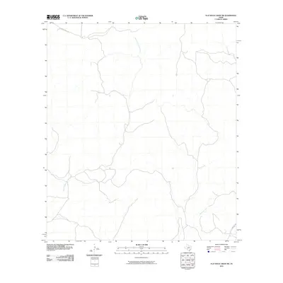
2010 Map of Flat Rock Creek NW
USGS Topo · Published 2010About this map
West Fork Sycamore Creek and its many intermittent tributaries carve a complex drainage system through this corner of Val Verde County. The terrain is characterized by the winding path of Sycamore Creek as it flows southeast toward the Edwards Plateau's edge. This 2010 survey reflects a landscape defined by ranching and rural infrastructure, with J S Murry Ranch Rd providing access to the northern reaches of the quadrangle. In the southeastern corner, Ranch Rd 2523 cuts across the drainage, marking one of the few improved transportation routes through this sparsely populated territory. The map illustrates the fundamental relationship between the available water sources and the local road network that follows the contours of the dry creek beds and ridgelines.
Find a feature on this map
4 named features on this map. Tap any name to fly to it.
Don’t see what you’re looking for? This feature index may not catch every label — zoom into the map to look around manually.
Map Details
Editions of this 2010 Flat Rock Creek NW Map
This is the sole edition of this map. No revisions or reprints were ever made.
Other maps of this area

1943 · Carta Valley
USGS Topo · 1:62,500

1944 · Flat Rock
USGS Topo · 1:62,500

1944 · Dry Devil
USGS Topo · 1:62,500

1944 · Devils Lake
USGS Topo · 1:62,500

1958 · Del Rio
USGS Topo · 1:250,000

1964 · Del Rio
USGS Topo · 1:250,000

1972 · Miers Ranch
USGS Topo · 1:24,000

1972 · Rough Canyon SE
USGS Topo · 1:24,000
1978 · Carta Valley
USGS Topo · 1:24,000
1978 · Carta Valley SE
USGS Topo · 1:24,000