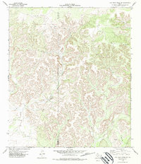
1978 Map of Flat Rock Creek NW
USGS Topo · Published 1978About this map
Sycamore Creek and its West Fork dominate this dissected Edwards County terrain, where the landscape is defined by intricate drainage patterns and sharp elevation changes. Surveyed in the mid-1970s, the map reveals a sparsely populated ranching environment along the Val Verde Co Edwards Co line. Human activity is marked by utility and extraction rather than settlement, evidenced by scattered Gravel Pits and a Drill Hole. A dedicated Landing Strip and various Jeep Trails suggest the necessity of specialized transport in this isolated corner of the state. The presence of an Indefinite Boundary adds a layer of historical interest for those studying land surveys and jurisdictional limits in west-central Texas.
Find a feature on this map
9 named features on this map. Tap any name to fly to it.
Don’t see what you’re looking for? This feature index may not catch every label — zoom into the map to look around manually.
Map Details
Editions of this 1978 Flat Rock Creek NW Map
This is the sole edition of this map. No revisions or reprints were ever made.
Other maps of this area

1943 · Carta Valley
USGS Topo · 1:62,500

1944 · Flat Rock
USGS Topo · 1:62,500

1944 · Dry Devil
USGS Topo · 1:62,500

1944 · Devils Lake
USGS Topo · 1:62,500

1958 · Del Rio
USGS Topo · 1:250,000

1964 · Del Rio
USGS Topo · 1:250,000

1972 · Miers Ranch
USGS Topo · 1:24,000

1972 · Rough Canyon SE
USGS Topo · 1:24,000
1978 · Carta Valley
USGS Topo · 1:24,000
1978 · Carta Valley SE
USGS Topo · 1:24,000