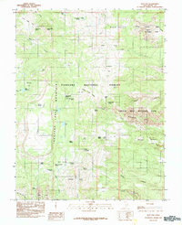
1985 Map of Flat Top
USGS Topo · Published 1985About this map
Thousand Lake Mountain dominates the western half of this Utah high-country landscape, marked by a dense concentration of volcanic and alpine features. In this 1985 survey, the transition between the lush higher elevations of the Fishlake National Forest and the stark geological exposures of Capitol Reef National Park is clearly defined. Notable landmarks such as Flat Top and the Waterpocket Fold illustrate the dramatic uplift and erosion patterns characteristic of Wayne County. The map details an intricate network of high-altitude water sources including Deep Creek Lake, Snow Lake, and the cluster of Round Lake Springs. Local names like Wiffs Pasture and Hells Hole provide geographical context for historic grazing and exploration in this portion of the Colorado Plateau.
Find a feature on this map
52 named features on this map. Tap any name to fly to it.
Don’t see what you’re looking for? This feature index may not catch every label — zoom into the map to look around manually.
Map Details
Editions of this 1985 Flat Top Map
This is the sole edition of this map. No revisions or reprints were ever made.
Other maps of this area

1885 · Fish Lake
USGS Topo · 1:250,000

1896 · Fish Lake
USGS Topo · 1:250,000

1952 · Notom 2 NW
USGS Topo · 1:24,000

1952 · Loa 1 SE
USGS Topo · 1:24,000

1952 · Notom 2 SE
USGS Topo · 1:24,000

1952 · Notom 2 SW
USGS Topo · 1:24,000

1952 · Notom 2 NE
USGS Topo · 1:24,000

1952 · Torrey
USGS Topo · 1:62,500

1952 · Loa 1 NE
USGS Topo · 1:24,000

1956 · Salina
USGS Topo · 1:250,000