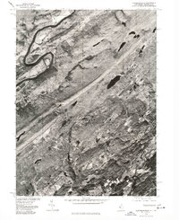
1976 Map of Flatbrookville
USGS Topo · Published 1978About this map
The Delaware River carves a sharp, dramatic bend through the northwest corner of this landscape, defining the topography near the settlement of Flatbrookville. Produced in cooperation with the Soil Conservation Service, this orthophotograph captures the distinct patterns of rural land use in the late 1970s. The image reveals a mosaic of dense woodlands interspersed with the cleared fields and farmsteads of Stillwater and Spring Valley.
Find a feature on this map
6 named features on this map. Tap any name to fly to it.
Don’t see what you’re looking for? This feature index may not catch every label — zoom into the map to look around manually.
Map Details
Editions of this 1976 Flatbrookville Map
This is the sole edition of this map. No revisions or reprints were ever made.
Other maps of this area

1888 · Hackettstown
USGS Topo · 1:62,500

1891 · Wallpack
USGS Topo · 1:62,500

1891 · Delaware Water Gap
USGS Topo · 1:62,500

1893 · Delaware Water Gap
USGS Topo · 1:62,500

1893 · Wallpack
USGS Topo · 1:62,500

1894 · Hackettstown
USGS Topo · 1:62,500

1898 · Hackettstown
USGS Topo · 1:62,500

1900 · Raritan
USGS Topo · 1:125,000

1905 · Raritan
USGS Topo · 1:125,000

1905 · Hackettstown
USGS Topo · 1:62,500
Featured Places
- Blairstown, NJ
- Stillwater Township, NJ
- Fredon Township, NJ
- Hardwick Township, NJ
- Flatbrookville, Walpack Township