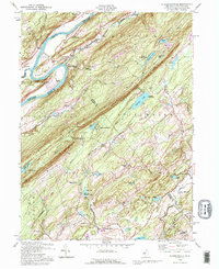
1992 Map of Flatbrookville
USGS Topo · Published 1995About this map
The Delaware River defines the western edge of this landscape, forming the dramatic Wallpack Bend around Sambo Island. In the early 1990s, the terrain transitions from the river valley up the steep slopes of Kittatinny Mountain, where the Appalachian Trail follows the ridge line through Catfish Pond Gap. This region is characterized by a high density of organized camps, including Camp No-Be-Bo-Sco, Camp Mohican, and the Princeton Summer Camp near Bass Lake. Small settlements like Flatbrookville and Millbrook sit along the narrow valleys, while the Walpack State WMA covers much of the high ground. Local history is preserved in sites such as the Lower Wallpack Cem and the river-crossing point at Smith Ferry.
Find a feature on this map
60 named features on this map. Tap any name to fly to it.
Don’t see what you’re looking for? This feature index may not catch every label — zoom into the map to look around manually.
Map Details
Editions of this 1992 Flatbrookville Map
This is the sole edition of this map. No revisions or reprints were ever made.
Other maps of this area

1888 · Hackettstown
USGS Topo · 1:62,500

1891 · Wallpack
USGS Topo · 1:62,500

1891 · Delaware Water Gap
USGS Topo · 1:62,500

1893 · Delaware Water Gap
USGS Topo · 1:62,500

1893 · Wallpack
USGS Topo · 1:62,500

1894 · Hackettstown
USGS Topo · 1:62,500

1898 · Hackettstown
USGS Topo · 1:62,500

1900 · Raritan
USGS Topo · 1:125,000

1905 · Raritan
USGS Topo · 1:125,000

1905 · Hackettstown
USGS Topo · 1:62,500
Featured Places
- Blairstown, NJ
- Stillwater Township, NJ
- Fredon Township, NJ
- Hardwick Township, NJ
- Flatbrookville, Walpack Township