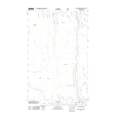
2011 Map of Flatiron Mountain
USGS Topo · Published 2011About this map
Flatiron Mountain and its surrounding peaks dominate this part of the Kootenai National Forest in northwestern Montana. The landscape is defined by high-elevation hydrology, where Lake Rene and Rainbow Lake feed into a complex system of drainages, including the South Fork Yaak River and the headwaters of Seventeenmile Creek. This 2011 survey illustrates the modern road network and forest management access, specifically highlighting Pipe Creek Rd as a primary corridor through the mountainous terrain. Between Indian Peak and Chief Peak, the terrain gives way to numerous named watercourses such as Papoose Creek, Sheepherder Creek, and Clay Creek. These features demonstrate the rugged, high-country character of Lincoln County, where seasonal waters and prominent ridges like Clay Mountain and Sheepherder Mountain dictate the local geography.
Find a feature on this map
21 named features on this map. Tap any name to fly to it.
Don’t see what you’re looking for? This feature index may not catch every label — zoom into the map to look around manually.
Map Details
Editions of this 2011 Flatiron Mountain Map
This is the sole edition of this map. No revisions or reprints were ever made.
Other maps of this area

1957 · Kalispell
USGS Topo · 1:250,000

1960 · Kalispell
USGS Topo · 1:250,000

1961 · Kalispell
USGS Topo · 1:250,000

1963 · Yaak
USGS Topo · 1:24,000

1963 · Turner Mountain
USGS Topo · 1:24,000

1963 · Sylvanite
USGS Topo · 1:24,000

1963 · Pulpit Mountain
USGS Topo · 1:24,000

1963 · Pink Mountain
USGS Topo · 1:24,000

1963 · Clark Mountain
USGS Topo · 1:24,000
1963 · Flatiron Mountain
USGS Topo · 1:24,000