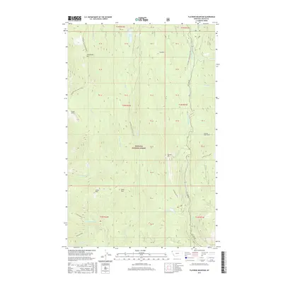
2017 Map of Flatiron Mountain
USGS Topo · Published 2017About this map
Kootenai National Forest dominates this section of Lincoln County, where the high ridges of the Purcell Mountains define the local topography. This 2017 survey details a landscape carved by the S Fork Yaak River and several significant drainages, including Pipe Cr and Seventeenmile Cr. The terrain is marked by prominent peaks such as Chief Peak, Indian Peak, and Flatiron Mtn, which sits just above Flatiron Ridge. High-elevation water bodies like Lake Rene and Rainbow Lake provide essential landmarks within the dense forest canopy.
Find a feature on this map
36 named features on this map. Tap any name to fly to it.
Don’t see what you’re looking for? This feature index may not catch every label — zoom into the map to look around manually.
Map Details
Editions of this 2017 Flatiron Mountain Map
This is the sole edition of this map. No revisions or reprints were ever made.
Other maps of this area

1957 · Kalispell
USGS Topo · 1:250,000

1960 · Kalispell
USGS Topo · 1:250,000

1961 · Kalispell
USGS Topo · 1:250,000

1963 · Yaak
USGS Topo · 1:24,000

1963 · Turner Mountain
USGS Topo · 1:24,000

1963 · Sylvanite
USGS Topo · 1:24,000

1963 · Pulpit Mountain
USGS Topo · 1:24,000

1963 · Pink Mountain
USGS Topo · 1:24,000

1963 · Clark Mountain
USGS Topo · 1:24,000
1963 · Flatiron Mountain
USGS Topo · 1:24,000