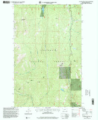
1997 Map of Flatiron Mountain
USGS Topo · Published 2000About this map
Flatiron Mountain and its surrounding peaks dominate this part of the Kootenai National Forest during the late twentieth century. This terrain, mapped with high precision, shows the watershed of the South Fork Yaak River as it receives tributaries like Zulu Creek and Smoot Creek. To the west, the landscape rises sharply toward Sheepherder Mountain and Indian Peak, punctuated by high-altitude features like Lake Rene. The presence of a Ranger Station near the center of the sheet reflects the active federal management of these timberlands and drainages. The complex network of forest roads and trails reveals the managed access through the Seventeenmile Creek and Pipe Creek corridors, providing an exact record of the region's topography before more modern shifts in forest use and conservation priorities.
Find a feature on this map
22 named features on this map. Tap any name to fly to it.
Don’t see what you’re looking for? This feature index may not catch every label — zoom into the map to look around manually.
Map Details
Editions of this 1997 Flatiron Mountain Map
This is the sole edition of this map. No revisions or reprints were ever made.
Other maps of this area

1957 · Kalispell
USGS Topo · 1:250,000

1960 · Kalispell
USGS Topo · 1:250,000

1961 · Kalispell
USGS Topo · 1:250,000

1963 · Yaak
USGS Topo · 1:24,000

1963 · Turner Mountain
USGS Topo · 1:24,000

1963 · Sylvanite
USGS Topo · 1:24,000

1963 · Pulpit Mountain
USGS Topo · 1:24,000

1963 · Pink Mountain
USGS Topo · 1:24,000

1963 · Clark Mountain
USGS Topo · 1:24,000
1963 · Flatiron Mountain
USGS Topo · 1:24,000