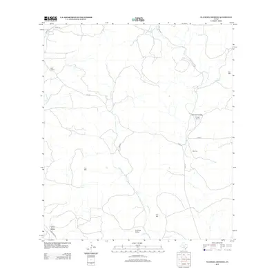
2012 Map of Flatrock Crossing
USGS Topo · Published 2012About this map
Miller Cem sits as a quiet landmark amidst a landscape of high ridges and winding creek beds in this rural Texas drainage system. The terrain is defined by the branching network of Seco Cr and its tributaries, including Little Seco Cr and Bee Cr, which have carved deep features such as Wolf Hollow and Armadillo Hollow. This 2012 survey illustrates the sparse, high-country character of the area, where isolated peaks like Holy Mtn, Flag Mtn, and Split Mtn rise above the drainage basins. Human presence is largely confined to the winding paths of Seco Rd and Ranch Road 187, connecting remote points like Flatrock Crossing Through Hollow and the waters of Richter Spring. The map provides a detailed view of the natural water sources, including Cherry Spring, that have historically influenced land use in this part of Medina County.
Find a feature on this map
25 named features on this map. Tap any name to fly to it.
Don’t see what you’re looking for? This feature index may not catch every label — zoom into the map to look around manually.
Map Details
Editions of this 2012 Flatrock Crossing Map
This is the sole edition of this map. No revisions or reprints were ever made.
Other maps of this area

1898 · Uvalde
USGS Topo · 1:125,000

1899 · Uvalde
USGS Topo · 1:125,000

1954 · San Antonio
USGS Topo · 1:250,000

1956 · Sabinal
USGS Topo · 1:62,500

1956 · Tarpley
USGS Topo · 1:62,500

1956 · Utopia
USGS Topo · 1:62,500

1957 · San Antonio
USGS Topo · 1:250,000
1964 · Tarpley
USGS Topo · 1:24,000
1964 · Seco Pass
USGS Topo · 1:24,000
1969 · Vanderpool
USGS Topo · 1:24,000