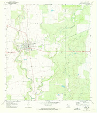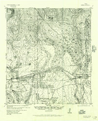
1956 Map of Sabinal
USGS Topo · Published 1956About this map
The intersection of the Galveston Harrisburg and San Antonio Railway System (Southern Pacific) and the Fort Clark-San Antonio Road anchors this landscape of the Texas Hill Country transition. While the town of Sabinal serves as a primary hub for the region, the map reveals a decentralized network of significant family-owned holdings, including the Reinhardt Ranch, Kennedy Ranch, and Ellsen Ranch, which speak to the area's established ranching heritage. Near the eastern edge, the presence of the Brick Yard at D'Hanis points to a specialized local industry that utilized the region's natural resources. Water remains the critical factor for both settlement and transit, as evidenced by the numerous named pools like Cedar Waterhole and the prominent course of the Sabinal River. The Seco Siding along the rail line further highlights the shipping points essential for moving goods through this largely rural expanse.
Find a feature on this map
28 named features on this map. Tap any name to fly to it.
Don’t see what you’re looking for? This feature index may not catch every label — zoom into the map to look around manually.
Map Details
Editions of this 1956 Sabinal Map
This is the sole edition of this map. No revisions or reprints were ever made.
Historical Maps of Sabinal Through Time
7 maps found