1964 Map of Yancey
USGS Topo · Published 1967About this map
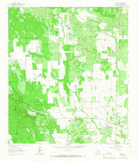
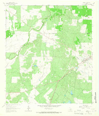
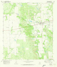
Yancey anchors this rural Medina County landscape, serving as a concentrated point of settlement amidst a network of large ranch holdings and creek drainages. The 1964 survey captures the community and its surrounding landmarks, such as Yancey Cem and the nearby Styers Cem. The terrain is defined by the winding paths of Tehuacana Creek and Seco Creek, with Squirrel Creek cutting through the southwestern corner. North of the town, the Taylor-Ina Oil Field points to the area's subterranean resources, while surface land use is dominated by large estates like Hidden Valley Ranch and Hood Ranch. The presence of several Gravel Pits and landmarks like Red Hill suggest an economy tied to both extraction and livestock, mapping a quiet transition between the brush country and the Balcones Escarpment foothills.
Find a feature on this map
15 named features on this map. Tap any name to fly to it.
Don’t see what you’re looking for? This feature index may not catch every label — zoom into the map to look around manually.
Map Details
Editions of this 1964 Yancey Map
This is the sole edition of this map. No revisions or reprints were ever made.
Other maps of this area
1928 · Frio Town
USGS Topo · 1:62,500

1954 · San Antonio
USGS Topo · 1:250,000
1956 · Sabinal
USGS Topo · 1:62,500
1956 · New Fountain
USGS Topo · 1:62,500

1957 · San Antonio
USGS Topo · 1:250,000
1964 · Moore
USGS Topo · 1:24,000
1964 · Wilson Ranch
USGS Topo · 1:24,000
1964 · Biry
USGS Topo · 1:24,000
1970 · Murphy School
USGS Topo · 1:24,000
1970 · D'hanis
USGS Topo · 1:24,000