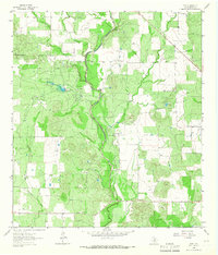
1964 Map of Biry
USGS Topo · Published 1967About this map
Taylor Ina Oil Field dominates the western landscape of this Medina County region, where industrial extraction and ranching intersect. The terrain is defined by the winding course of Hondo Creek, which flows south alongside a private Landing Strip and the Adams Ranch. This mid-century survey captures a rural Texas economy transitioning through resource development, evidenced by numerous Oil Wells and Gas Wells scattered across the brushland. Small community anchors remain visible at Biry and Rackley, while the Mussman Cem provides a specific point of interest for genealogists tracing local family histories. Water remains the primary geographical marker, with the confluence of Live Oak Slough and Brier Branch feeding the larger creek systems that have shaped the settlement patterns of the area.
Find a feature on this map
16 named features on this map. Tap any name to fly to it.
Don’t see what you’re looking for? This feature index may not catch every label — zoom into the map to look around manually.
Map Details
Editions of this 1964 Biry Map
This is the sole edition of this map. No revisions or reprints were ever made.
Other maps of this area

1942 · Natalia
USGS Topo · 1:62,500

1954 · San Antonio
USGS Topo · 1:250,000

1956 · New Fountain
USGS Topo · 1:62,500

1957 · San Antonio
USGS Topo · 1:250,000

1964 · Ghost Hill
USGS Topo · 1:24,000

1964 · Castroville
USGS Topo · 1:24,000

1964 · Devine
USGS Topo · 1:24,000
1964 · Moore
USGS Topo · 1:24,000
1964 · Wilson Ranch
USGS Topo · 1:24,000

1964 · Yancey
USGS Topo · 1:24,000