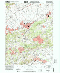
1999 Map of Fleetwood
USGS Topo · Published 2001About this map
Oley Furnace and the surrounding agricultural valley define the southern landscape of this Berks County survey, where the Monocacy Creek and Little Manatawny Creek drain through a terrain dotted with rural institutions. The map records a dense network of local schools serving scattered settlements, including Stimmels Sch, Seidel Sch, and the Dreibelbis Sch. These small community hubs are joined by centers of worship like St Peters Ch and Union Ch, reflecting the deep-rooted social fabric of the Pennsylvania Dutch country at the close of the twentieth century.
Find a feature on this map
62 named features on this map. Tap any name to fly to it.
Don’t see what you’re looking for? This feature index may not catch every label — zoom into the map to look around manually.
Map Details
Editions of this 1999 Fleetwood Map
This is the sole edition of this map. No revisions or reprints were ever made.
Other maps of this area

1894 · Reading
USGS Topo · 1:62,500

1902 · Boyertown
USGS Topo · 1:62,500

1902 · Slatington
USGS Topo · 1:62,500

1909 · Hamburg
USGS Topo · 1:62,500

1911 · Hamburg
USGS Topo · 1:62,500

1913 · Reading
USGS Topo · 1:62,500

1915 · Reading
USGS Topo · 1:62,500

1937 · Allentown West
USGS Topo · 1:48,000

1942 · Allentown West
USGS Topo · 1:62,500

1943 · Manatawny
USGS Topo · 1:31,680