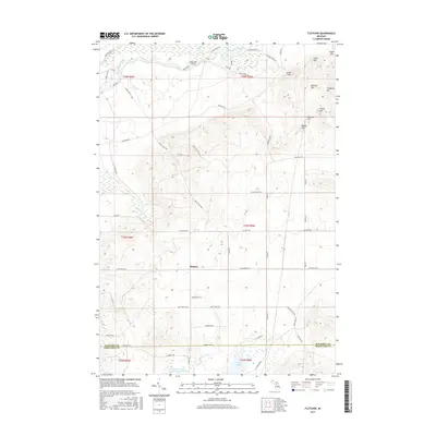
2017 Map of Fletcher
USGS Topo · Published 2017About this map
The Manistee River flows through the northern reaches of this Kalkaska County landscape, where the small settlement of Fletcher sits at a crossroads in the central section of the map. This 2017 survey reveals a terrain defined by glacial features and water management, including the extensive Big Cannon Cr Number Two Flooding and Big Cannon Cr that drain toward Grass Lake at the southern boundary with Missaukee County. A cluster of named peaks dominates the northeast, including Smith Hill, Ester Hill, and Lindquist Hill, rising above a network of section-line roads and timber trails. In the northwest, the King Trout Airport serves as a small aviation outpost near the river's bend. The map illustrates a contemporary balance between recreational land use and the region's natural hydrology, featuring numerous tributaries like Goose Creek, Portage Creek, and Big Devils Cr that carve through the undulating elevations.
Find a feature on this map
62 named features on this map. Tap any name to fly to it.
Don’t see what you’re looking for? This feature index may not catch every label — zoom into the map to look around manually.
Map Details
Editions of this 2017 Fletcher Map
This is the sole edition of this map. No revisions or reprints were ever made.
Other maps of this area

1949 · Black Creek
USGS Topo · 1:24,000

1949 · Fletcher
USGS Topo · 1:62,500

1950 · Cote Dame Marie
USGS Topo · 1:24,000

1950 · Fletcher
USGS Topo · 1:24,000

1950 · Lake Margrethe
USGS Topo · 1:24,000

1954 · Traverse City
USGS Topo · 1:250,000

1956 · Kalkaska
USGS Topo · 1:62,500

1956 · Houghton Lake
USGS Topo · 1:62,500

1956 · Lake City
USGS Topo · 1:62,500

1958 · Traverse City
USGS Topo · 1:250,000