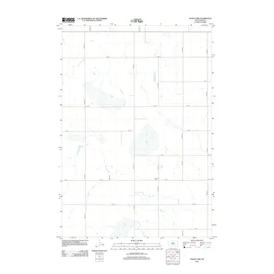
2012 Map of Flight Lake
USGS Topo · Published 2012About this map
The rolling plains of Potter County, South Dakota, are defined by a rhythmic grid of rural roads and scattered prairie depressions. Central to this landscape is Flight Lake, a shallow body of water that anchors the surrounding sections of agricultural land. To the south, the terrain descends toward Green Lake, highlighting the drainage patterns of this glacially influenced region. A notable point of historical interest is the Pembroke Cem, situated along 154 St between 311th Ave and 312th Ave. This small cemetery serves as a primary genealogical landmark for a township that remains largely open and agricultural, with the map recording the precise network of section-line roads like 309th Ave and 151st St that facilitate local movement between the vast prairie tracts.
Find a feature on this map
17 named features on this map. Tap any name to fly to it.
Don’t see what you’re looking for? This feature index may not catch every label — zoom into the map to look around manually.
Map Details
Editions of this 2012 Flight Lake Map
This is the sole edition of this map. No revisions or reprints were ever made.
Other maps of this area

1953 · McIntosh
USGS Topo · 1:250,000

1954 · Aberdeen
USGS Topo · 1:250,000

1956 · Aberdeen
USGS Topo · 1:250,000

1958 · McIntosh
USGS Topo · 1:250,000

1968 · Akaska
USGS Topo · 1:24,000

1970 · Lake Hurley NE
USGS Topo · 1:24,000
1970 · Lake Hurley SE
USGS Topo · 1:24,000

1974 · Lowry
USGS Topo · 1:24,000

1974 · Hoven
USGS Topo · 1:24,000

1974 · Hoven Muni. Airport
USGS Topo · 1:24,000