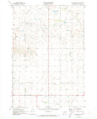
1970 Map of Lake Hurley SE
USGS Topo · Published 1973About this map
Little Cheyenne Creek meanders through the heart of this Potter County landscape, defining the topography across the townships of Appomattox and Lincoln. In 1970, the area remained a sparsely settled agricultural expanse, marked by small country schoolhouses like Mascher Sch and Sanner Sch. The influence of the former rail system is prominent, evidenced by the Old Grade Railroad and Old Railroad Grade that cut across the northern and southern sections, tracing a legacy of transportation that once connected these rural prairie communities.
Find a feature on this map
11 named features on this map. Tap any name to fly to it.
Don’t see what you’re looking for? This feature index may not catch every label — zoom into the map to look around manually.
Map Details
Editions of this 1970 Lake Hurley SE Map
This is the sole edition of this map. No revisions or reprints were ever made.
Other maps of this area

1953 · Huron
USGS Topo · 1:250,000

1953 · McIntosh
USGS Topo · 1:250,000

1954 · Aberdeen
USGS Topo · 1:250,000

1954 · Pierre
USGS Topo · 1:250,000

1954 · Huron
USGS Topo · 1:250,000

1956 · Aberdeen
USGS Topo · 1:250,000

1958 · Pierre
USGS Topo · 1:250,000

1958 · McIntosh
USGS Topo · 1:250,000

1970 · Steamboat Creek
USGS Topo · 1:24,000

1970 · Lake Hurley
USGS Topo · 1:24,000