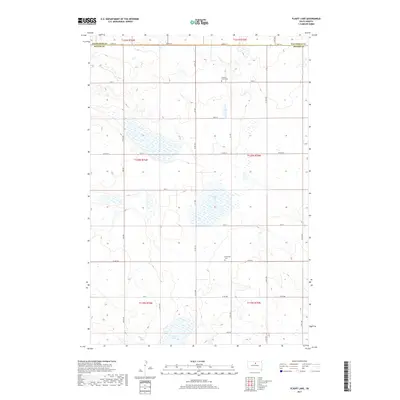
2017 Map of Flight Lake
USGS Topo · Published 2017About this map
Flight Lake sits at the center of this rural prairie landscape in Potter County, showing a region defined by its wide section-line road grid and seasonal wetlands. The map documents a sparsely populated agricultural area north of Gettysburg, where the township boundaries of t120n r75w and t121n r76w meet. Local history is anchored by the presence of Prairie Grove Cem and Pembroke Cem, which serve as small landmarks among the expansive fields. The road network, including Co Rd 155 and Co Rd 819, follows the rigid Public Land Survey System, illustrating how modern transportation still adheres to the nineteenth-century division of the South Dakota plains. To the south, Green Lake provides another significant hydrographic feature in a territory primarily occupied by farming and ranching operations.
Find a feature on this map
32 named features on this map. Tap any name to fly to it.
Don’t see what you’re looking for? This feature index may not catch every label — zoom into the map to look around manually.
Map Details
Editions of this 2017 Flight Lake Map
This is the sole edition of this map. No revisions or reprints were ever made.
Other maps of this area

1953 · McIntosh
USGS Topo · 1:250,000

1954 · Aberdeen
USGS Topo · 1:250,000

1956 · Aberdeen
USGS Topo · 1:250,000

1958 · McIntosh
USGS Topo · 1:250,000

1968 · Akaska
USGS Topo · 1:24,000

1970 · Lake Hurley NE
USGS Topo · 1:24,000
1970 · Lake Hurley SE
USGS Topo · 1:24,000

1974 · Lowry
USGS Topo · 1:24,000

1974 · Hoven
USGS Topo · 1:24,000

1974 · Hoven Muni. Airport
USGS Topo · 1:24,000