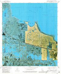
1979 Map of Floating Turf Bayou
USGS Topo · Published 1980About this map
Rockefeller State Wildlife Refuge and Game Preserve dominates the southern reaches of this coastal landscape, protecting a complex network of marshes and water bodies along the Gulf coast. In the late 1970s, this area of Vermilion Parish and Cameron Parish was characterized by its intricate hydrology, where the namesake Floating Turf Bayou winds through wetlands toward the massive expanse of White Lake. The presence of several Oil Wells and a prominent Lookout Tower speaks to the region's dual identity as a managed conservation area and a site for industrial extraction. Navigation through this water-logged terrain relied on established channels like Big Pecan Bayou and named island landmarks such as Long Island, while smaller bodies like Grande Volle Lake and Bear Lake pockmark the transitional zone between open water and marsh.
Find a feature on this map
12 named features on this map. Tap any name to fly to it.
Don’t see what you’re looking for? This feature index may not catch every label — zoom into the map to look around manually.
Map Details
Editions of this 1979 Floating Turf Bayou Map
This is the sole edition of this map. No revisions or reprints were ever made.
Other maps of this area

1932 · Constance Bayou NE
USGS Topo · 1:31,680

1932 · Constance Bayou SW
USGS Topo · 1:31,680

1932 · Pecan Island SW
USGS Topo · 1:31,680

1932 · Constance Bayou SE
USGS Topo · 1:31,680

1932 · Constance Bayou NW
USGS Topo · 1:31,680

1945 · Pecan Island NW
USGS Topo · 1:31,680

1946 · Schooner Bayou SW
USGS Topo · 1:31,680

1951 · Pecan Island
USGS Topo · 1:62,500

1953 · Jacks Point Island
USGS Topo · 1:24,000

1954 · Grand Lake East SE
USGS Topo · 1:31,680