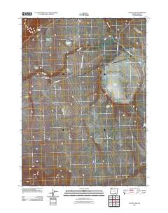
2011 Map of Flook Lake
USGS Topo · Published 2011About this map
The Hart Mountain Antelope Refuge dominates this high desert landscape, preserving a critical habitat for native wildlife in southeastern Oregon. This 2011 survey reveals a complex network of seasonal water sources and named landforms that define life in this arid basin. Significant water features like Flook Lake, Poker Jim Lake, and Reservoir Lake are scattered across the terrain, while reliable water points such as Poker Jim Spring and Antelope Spring provided essential resources for local ranching operations. The lone evidence of historic settlement is the Flook Ranch, situated north of the lakebed near the junction of Frenchglen Rd and Pistol Spring Rd. The topography is further marked by distinct geological features including Division Canyon, Rattlesnake Draw, and the high ground of Blizzard Ridge, reflecting the stark character of Lake County's interior.
Find a feature on this map
13 named features on this map. Tap any name to fly to it.
Don’t see what you’re looking for? This feature index may not catch every label — zoom into the map to look around manually.
Map Details
Editions of this 2011 Flook Lake Map
This is the sole edition of this map. No revisions or reprints were ever made.
Other maps of this area

1955 · Adel
USGS Topo · 1:250,000

1957 · Adel
USGS Topo · 1:250,000

1958 · Adel
USGS Topo · 1:250,000

1962 · Adel
USGS Topo · 1:250,000

1966 · Bluejoint Lake East
USGS Topo · 1:24,000

1967 · Campbell Lake
USGS Topo · 1:24,000

1967 · Flook Lake
USGS Topo · 1:24,000

1967 · Bluejoint Lake West
USGS Topo · 1:24,000

1967 · Warner Peak
USGS Topo · 1:24,000

1967 · Swede Knoll
USGS Topo · 1:24,000