
1967 Map of Swede Knoll
USGS Topo · Published 1969About this map
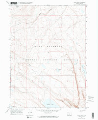
Hart Mountain National Antelope Refuge dominates this 1967 survey of Lake County, Oregon. The landscape is defined by a series of high-altitude basins and dry lake beds, including Desert Lake and the smaller Fitzgerald Lake. Located near the western edge of the Great Basin, this area shows a high-desert drainage system characterized by seasonal water bodies and ephemeral features such as Deer Creek and Link Lake.
Find a feature on this map
11 named features on this map. Tap any name to fly to it.
Don’t see what you’re looking for? This feature index may not catch every label — zoom into the map to look around manually.
Map Details
Editions of this 1967 Swede Knoll Map
2 editions found
Other maps of this area

1955 · Adel
USGS Topo · 1:250,000

1957 · Adel
USGS Topo · 1:250,000

1958 · Adel
USGS Topo · 1:250,000

1962 · Adel
USGS Topo · 1:250,000

1967 · Jacobs Reservoir
USGS Topo · 1:24,000

1967 · Campbell Lake
USGS Topo · 1:24,000

1967 · Flook Lake
USGS Topo · 1:24,000

1967 · Alger Lake
USGS Topo · 1:24,000

1967 · Warner Peak
USGS Topo · 1:24,000

1971 · Murphy Waterholes
USGS Topo · 1:24,000