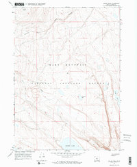
1967 Map of Swede Knoll
USGS Topo · Published 1969About this map
Hart Mountain National Antelope Refuge dominates this landscape, preserving a high-desert environment defined by the prominent ridge of Hart Mountain. The 1967 field check reveals a network of seasonal water bodies and drainages, including the large expanse of Desert Lake and smaller catchments like Fitzgerald Lake and Link Lake. Topographic details highlight the relief of Swede Knoll and the descent of Black Canyon in the north, while ephemeral flows are traced through Deer Creek and Robinson Draw. A sparse network of Jeep Trails provides the primary means of access through this protected basin-and-range territory, illustrating the remote character of Lake County's high plateau before modern infrastructure expansion. The map serves as a detailed record of the refuge's hydrology and landform before later environmental shifts impacted these delicate desert sinks.
Find a feature on this map
15 named features on this map. Tap any name to fly to it.
Don’t see what you’re looking for? This feature index may not catch every label — zoom into the map to look around manually.
Map Details
Editions of this 1967 Swede Knoll Map
2 editions found
Other maps of this area

1955 · Adel
USGS Topo · 1:250,000

1957 · Adel
USGS Topo · 1:250,000

1958 · Adel
USGS Topo · 1:250,000

1962 · Adel
USGS Topo · 1:250,000

1967 · Jacobs Reservoir
USGS Topo · 1:24,000

1967 · Campbell Lake
USGS Topo · 1:24,000

1967 · Flook Lake
USGS Topo · 1:24,000

1967 · Alger Lake
USGS Topo · 1:24,000

1967 · Warner Peak
USGS Topo · 1:24,000

1967 · Swede Knoll
USGS Topo · 1:24,000