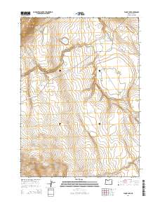
2014 Map of Flook Lake
USGS Topo · Published 2014About this map
Flook Lake and the surrounding high desert of Lake County are defined by a complex network of seasonal water sources and distinct geological formations. The landscape is marked by the presence of Poker Jim Lake and Reservoir Lake, reflecting a region where water management and natural springs like Poker Jim Spring and Antelope Spring are vital to the local ecology. The terrain shifts from the elevations of Blizzard Ridge and Swede Knoll to the carved depths of Division Canyon and Rattlesnake Draw.
Find a feature on this map
17 named features on this map. Tap any name to fly to it.
Don’t see what you’re looking for? This feature index may not catch every label — zoom into the map to look around manually.
Map Details
Editions of this 2014 Flook Lake Map
This is the sole edition of this map. No revisions or reprints were ever made.
Other maps of this area

1955 · Adel
USGS Topo · 1:250,000

1957 · Adel
USGS Topo · 1:250,000

1958 · Adel
USGS Topo · 1:250,000

1962 · Adel
USGS Topo · 1:250,000

1966 · Bluejoint Lake East
USGS Topo · 1:24,000

1967 · Campbell Lake
USGS Topo · 1:24,000

1967 · Flook Lake
USGS Topo · 1:24,000

1967 · Bluejoint Lake West
USGS Topo · 1:24,000

1967 · Warner Peak
USGS Topo · 1:24,000

1967 · Swede Knoll
USGS Topo · 1:24,000