
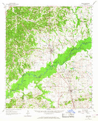
1962 Map of Flora
USGS Topo · Published 1964About this map
Big Black River meanders across this landscape, forming the boundary between Yazoo, Madison, and Hinds counties. The early 1960s character of the region is defined by a mix of agricultural bottomlands and industrial development, most notably at the Kearney Park Industrial Area and the scattered Oil Wells near Oil City. Transportation follows the corridor of the Illinois Central railroad, which connects the primary settlements of Bentonia and Flora.
Find a feature on this map
83 named features on this map. Tap any name to fly to it.
Don’t see what you’re looking for? This feature index may not catch every label — zoom into the map to look around manually.
Map Details
Editions of this 1962 Flora Map
2 editions found
Other maps of this area

1903 · Jackson
USGS Topo · 1:125,000

1905 · Jackson
USGS Topo · 1:48,000

1908 · Jackson
USGS Topo · 1:62,500

1934 · Raymond
USGS Topo · 1:48,000

1937 · Raymond
USGS Topo · 1:62,500

1938 · Edwards
USGS Topo · 1:62,500

1940 · Mechanicsburg
USGS Topo · 1:62,500

1942 · Raymond
USGS Topo · 1:62,500

1955 · Jackson
USGS Topo · 1:250,000

1961 · Jackson
USGS Topo · 1:250,000