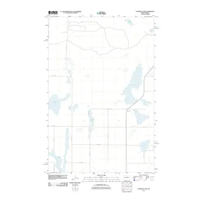
2011 Map of Florence Lake
USGS Topo · Published 2011About this map
Florence Lake and its surrounding alkali basins define this Burleigh County landscape, where water bodies frequently dictate the path of the section-line road network. This interior region of North Dakota is characterized by numerous glacially-formed basins, including the elongated Salt Lake to the east and the sprawling Pelican Lake to the west. The human imprint on the land is represented by a strict grid of rural routes such as 288th St NE and 448th Ave NE, which navigate around the natural depressions and marshy margins of O'Brien Lake and West Lake. This 2011 edition shows the area's hydrology at a specific modern interval, reflecting the seasonal and climatic fluctuations of these North Dakota prairie potholes before later shifts in water levels or agricultural land use.
Find a feature on this map
19 named features on this map. Tap any name to fly to it.
Don’t see what you’re looking for? This feature index may not catch every label — zoom into the map to look around manually.
Map Details
Editions of this 2011 Florence Lake Map
This is the sole edition of this map. No revisions or reprints were ever made.
Other maps of this area

1954 · McClusky
USGS Topo · 1:250,000

1958 · McClusky
USGS Topo · 1:250,000

1959 · McClusky
USGS Topo · 1:24,000

1960 · Horse Lake
USGS Topo · 1:24,000

1960 · Florence Lake
USGS Topo · 1:24,000

1960 · Denhoff
USGS Topo · 1:24,000
1978 · Goodrich SW
USGS Topo · 1:24,000
1978 · Goodrich West
USGS Topo · 1:24,000

1979 · Canfield Lake
USGS Topo · 1:24,000
1979 · Wing
USGS Topo · 1:24,000