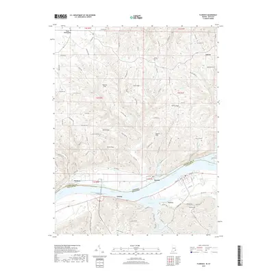
2019 Map of Florence
USGS Topo · Published 2019About this map
The Ohio River serves as the central artery and state boundary dividing the Kentucky and Indiana hillsides in this 2019 survey. Along the southern banks, the community of Warsaw is defined by its position near the mouth of Craigs Creek, while the settlement of Florence sits further west near the river's bend. The landscape is heavily characterized by a series of prominent finger ridges, including McCreary Ridge, Scott Ridge, and Beatty Ridge, which dictate the winding paths of rural roads and the location of high-ground settlements like Pleasant Ridge. Genealogists will find interest in the documented locations of Antioch Cem near the town of Antioch and the Quercus Grove Cem to the west. The map illustrates a deeply dissected topography where numerous tributaries such as Log-Lick Cr and Turtle Cr have carved the terrain, creating a complex network of hollows and ridges that have shaped local transport and settlement patterns for generations.
Find a feature on this map
94 named features on this map. Tap any name to fly to it.
Don’t see what you’re looking for? This feature index may not catch every label — zoom into the map to look around manually.
Map Details
Editions of this 2019 Florence Map
This is the sole edition of this map. No revisions or reprints were ever made.
Other maps of this area

1943 · Florence
USGS Topo · 1:24,000

1943 · Aberdeen
USGS Topo · 1:24,000

1943 · Vevay North
USGS Topo · 1:24,000

1943 · Rising Sun
USGS Topo · 1:24,000

1943 · Patriot
USGS Topo · 1:24,000

1943 · Vevay South
USGS Topo · 1:24,000

1950 · Glencoe
USGS Topo · 1:24,000

1951 · Florence
USGS Topo · 1:24,000

1951 · Rising Sun
USGS Topo · 1:24,000

1951 · Sanders
USGS Topo · 1:24,000