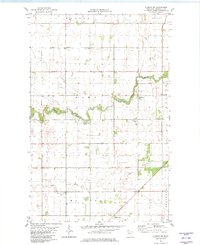
1982 Map of Florian SW
USGS Topo · Published 1982About this map
The winding course of the Middle River and Swift Coulee define this portion of Marshall County during the early 1980s. This agricultural landscape is organized around the township divisions of Wanger, Wright, Alma, Foldal, McCrea, and Comstock. Local civic and spiritual life is anchored by landmarks like the Townhall, St Johns Ch, and Alma Ch, along with the Mc Crea Cem. The terrain is marked by human modifications to the natural drainage, most notably County Ditch No 10, and industrial activity is present at various Gravel Pits north of the river. A prominent Pipeline cuts across the northeastern townships, reflecting the infrastructure supporting this rural Minnesota region at the time of the 1978 field check.
Find a feature on this map
19 named features on this map. Tap any name to fly to it.
Don’t see what you’re looking for? This feature index may not catch every label — zoom into the map to look around manually.
Map Details
Editions of this 1982 Florian SW Map
This is the sole edition of this map. No revisions or reprints were ever made.
Other maps of this area

1918 · Angus
USGS Topo · 1:62,500

1918 · Argyle
USGS Topo · 1:62,500

1918 · Warren
USGS Topo · 1:62,500

1952 · Thief River Falls
USGS Topo · 1:250,000

1954 · Stephen
USGS Topo · 1:62,500

1955 · Warren
USGS Topo · 1:62,500

1956 · Thief River Falls
USGS Topo · 1:250,000

1956 · Florian
USGS Topo · 1:62,500

1957 · Thief River Falls
USGS Topo · 1:250,000

1961 · Radium
USGS Topo · 1:24,000