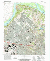
1994 Map of Florissant
USGS Topo · Published 1994About this map
The Missouri River defines the northwestern boundary of this suburban landscape, where the Car of Commerce Chute separates the mainland from the expansive Pelican Island County Park. To the south, the dense residential and industrial grids of Florissant, Hazelwood, and Ferguson dominate the terrain, reflecting the mid-to-late 20th-century expansion of northern St. Louis County. A complex network of major interchanges and primary roads like McDonnell Blvd serves the bustling Lambert St Louis International Airport in the southwest corner.
Find a feature on this map
97 named features on this map. Tap any name to fly to it.
Don’t see what you’re looking for? This feature index may not catch every label — zoom into the map to look around manually.
Map Details
Editions of this 1994 Florissant Map
This is the sole edition of this map. No revisions or reprints were ever made.
Other maps of this area

1888 · St. Louis
USGS Topo · 1:62,500

1924 · Robertson
USGS Topo · 1:24,000

1927 · Alton
USGS Topo · 1:62,500

1927 · St. Charles
USGS Topo · 1:62,500

1933 · Creve Coeur
USGS Topo · 1:24,000

1933 · Granite City
USGS Topo · 1:24,000

1933 · Clayton
USGS Topo · 1:24,000

1933 · Saint Charles
USGS Topo · 1:62,500

1934 · Alton
USGS Topo · 1:62,500

1935 · Granite City
USGS Topo · 1:24,000