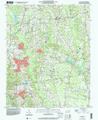
1998 Map of Flowers
USGS Topo · Published 2000About this map
Buffalo Creek and the Little River wind through this Johnston County landscape, defining a rural topography of small farming communities and family homesteads as they appeared in the late 1990s. The area is anchored by several crossroads settlements like Archers Lodge, Hocutts Crossroads, and Flowers, which serve as the historic social centers for the surrounding countryside. A dense network of family cemeteries, including the Whitley, Jeffrey, and Batten graveyards, provides a detailed record of the area's genealogical roots.
Find a feature on this map
39 named features on this map. Tap any name to fly to it.
Don’t see what you’re looking for? This feature index may not catch every label — zoom into the map to look around manually.
Map Details
Editions of this 1998 Flowers Map
This is the sole edition of this map. No revisions or reprints were ever made.
Other maps of this area

1902 · Kenly
USGS Topo · 1:62,500

1902 · Spring Hope
USGS Topo · 1:62,500

1903 · Kenly
USGS Topo · 1:62,500

1904 · Springhope
USGS Topo · 1:62,500

1953 · Raleigh
USGS Topo · 1:250,000

1954 · Raleigh
USGS Topo · 1:250,000

1964 · Flowers
USGS Topo · 1:24,000

1964 · Selma
USGS Topo · 1:62,500

1964 · Clayton
USGS Topo · 1:24,000

1964 · Powhatan
USGS Topo · 1:24,000