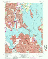
1966 Map of Flushing
USGS Topo · Published 1986About this map
Flushing and its surrounding coastal neighborhoods are mapped during a period of massive infrastructure growth and dense urban development. This 1966 survey, photorevised in 1979, illustrates the complex web of highways spanning the East River, including the Throgs Neck Bridge and Bronx Whitestone Bridge, which connected the expanding residential clusters of Whitestone, Bayside, and College Point with the industrial and institutional corridors of the Bronx.
Find a feature on this map
191 named features on this map. Tap any name to fly to it.
Don’t see what you’re looking for? This feature index may not catch every label — zoom into the map to look around manually.
Map Details
Editions of this 1966 Flushing Map
4 editions found
Other maps of this area

1889 · Brooklyn
USGS Topo · 1:62,500

1891 · Brooklyn
USGS Topo · 1:62,500

1891 · Harlem
USGS Topo · 1:62,500

1897 · Harlem
USGS Topo · 1:62,500

1897 · Brooklyn
USGS Topo · 1:62,500

1897 · Hempstead
USGS Topo · 1:62,500

1897 · Oyster Bay
USGS Topo · 1:62,500

1898 · Harlem
USGS Topo · 1:62,500

1898 · Hempstead
USGS Topo · 1:62,500

1898 · Brooklyn
USGS Topo · 1:62,500
Featured Places
- New York, NY
- North Hempstead, NY
- New Rochelle, NY
- Great Neck, North Hempstead
- Kings Point, North Hempstead