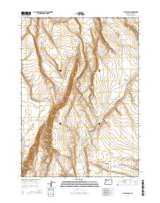
2014 Map of Flybee Lake
USGS Topo · Published 2014About this map
Open Valley dominates the central landscape of this Harney County quadrangle, where a series of ephemeral water sources supported the high desert cattle-ranching culture of southeastern Oregon. The 2014 survey documents a network of interior basins and depressions, including the named Flybee Lake, Flynn Lake, and Deep Canyon Lake. These seasonal features are joined by man-made or improved catchments like Open Valley Waterhole Number Three, illustrating the critical importance of water management in this arid region. The terrain is marked by distinctive geological formations such as Devils Canyon and the curiously named Hole in Rocks, while Smoky Hollow and Little Valley provide further definition to the local topography. This map serves as a detailed record of the Public Land Survey System boundaries, tracing the intersections of Townships 28, 29, and 30 South across Ranges 27 and 28 East.
Find a feature on this map
17 named features on this map. Tap any name to fly to it.
Don’t see what you’re looking for? This feature index may not catch every label — zoom into the map to look around manually.
Map Details
Editions of this 2014 Flybee Lake Map
This is the sole edition of this map. No revisions or reprints were ever made.
Other maps of this area

1955 · Burns
USGS Topo · 1:250,000

1955 · Adel
USGS Topo · 1:250,000

1957 · Adel
USGS Topo · 1:250,000

1958 · Burns
USGS Topo · 1:250,000

1958 · Adel
USGS Topo · 1:250,000

1959 · Burns
USGS Topo · 1:250,000

1962 · Adel
USGS Topo · 1:250,000

1971 · Clover Swale
USGS Topo · 1:24,000

1971 · Rock Camp Draw
USGS Topo · 1:24,000
1971 · Balls Lake
USGS Topo · 1:24,000