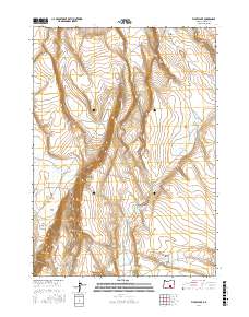
2017 Map of Flybee Lake
USGS Topo · Published 2017About this map
Flybee Lake and its surrounding high-desert hydrology define this section of Harney County, where the U.S. Geological Survey documented critical water sources in an arid landscape. The area is marked by significant topographical relief, from the depths of Deep Canyon in the north to the broad expanse of Open Valley in the south. These features reveal the vital importance of seasonal and permanent water collection for regional land use, specifically highlighted by named sites like Open Valley Waterhole Number Three. The landscape is a network of named drainages and hollows, including Smoky Hollow and Devils Canyon, which provide a detailed look at the basin-and-range character of the region. Distinctive landmarks such as Hole in Rocks and the western edge of Little Valley serve as essential orientation points within the township and range survey system.
Find a feature on this map
16 named features on this map. Tap any name to fly to it.
Don’t see what you’re looking for? This feature index may not catch every label — zoom into the map to look around manually.
Map Details
Editions of this 2017 Flybee Lake Map
This is the sole edition of this map. No revisions or reprints were ever made.
Other maps of this area

1955 · Burns
USGS Topo · 1:250,000

1955 · Adel
USGS Topo · 1:250,000

1957 · Adel
USGS Topo · 1:250,000

1958 · Burns
USGS Topo · 1:250,000

1958 · Adel
USGS Topo · 1:250,000

1959 · Burns
USGS Topo · 1:250,000

1962 · Adel
USGS Topo · 1:250,000

1971 · Clover Swale
USGS Topo · 1:24,000

1971 · Rock Camp Draw
USGS Topo · 1:24,000
1971 · Balls Lake
USGS Topo · 1:24,000