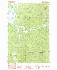
1985 Map of Foley Peak
USGS Topo · Published 1985About this map
The Nehalem River dictates the rugged character of this coastal Oregon landscape, winding through the heavily forested terrain of the Tillamook State Forest. At this time in the mid-1980s, the river corridor supports several small riverside locations, including Mohler, Wheeler, and the settlement of Batterson. The geography is defined by steep ridges and peaks, most notably Foley Peak and Crag Mountain, which rise above the many drainages feeding the Nehalem and Miami River. This survey reveals the transition from tidal lowlands at Gallagher Slough to the interior highlands where Nehalem Falls and Nehalem Falls Park provide public access to the river's natural features. The presence of a Gravel Pit and Barrow Pit along the north fork suggests the ongoing maintenance of the local timber and transportation networks, while family-named landmarks like Zaddach Creek and Foley Creek highlight the area's local heritage.
Find a feature on this map
34 named features on this map. Tap any name to fly to it.
Don’t see what you’re looking for? This feature index may not catch every label — zoom into the map to look around manually.
Map Details
Editions of this 1985 Foley Peak Map
This is the sole edition of this map. No revisions or reprints were ever made.
Other maps of this area

1937 · Nehalem
USGS Topo · 1:62,500

1937 · Enright
USGS Topo · 1:62,500

1939 · Saddle Mountain
USGS Topo · 1:62,500

1940 · Cape Falcon
USGS Topo · 1:62,500

1941 · Enright
USGS Topo · 1:62,500

1943 · Nehalem
USGS Topo · 1:62,500

1943 · Saddle Mtn.
USGS Topo · 1:62,500

1948 · Vancouver
USGS Topo · 1:250,000

1950 · Vancouver
USGS Topo · 1:250,000

1950 · Vancouver
USGS Topo · 1:250,000