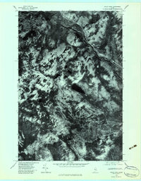
1979 Map of Foley Pond
USGS Topo · Published 1983About this map
North Branch Penobscot River winds through this heavily forested Somerset County landscape, its course and the surrounding timberland captured through high-altitude aerial photography in late 1979. This orthophotoquad provides an unfiltered visual record of the North Woods before the transition to modern digital mapping, highlighting the complex drainage patterns of Lane Brook and Cunningham Brook. The topography is dominated by the massif of Green Mountain, while the namesake Foley Pond sits as a dark anchor in the central terrain. Unlike traditional line-drawn maps, this imagery reveals the actual density of the forest cover and the intricate web of logging roads or trails that crisscross the area, offering a rare perspective on the scale of Maine's wilderness management during this era.
Find a feature on this map
5 named features on this map. Tap any name to fly to it.
Don’t see what you’re looking for? This feature index may not catch every label — zoom into the map to look around manually.
Map Details
Editions of this 1979 Foley Pond Map
This is the sole edition of this map. No revisions or reprints were ever made.
Other maps of this area

1949 · Jackman
USGS Topo · 1:250,000

1954 · Seboomook Lake
USGS Topo · 1:62,500

1954 · St. John Pond
USGS Topo · 1:62,500

1954 · Presque Isle
USGS Topo · 1:250,000

1954 · Millinocket
USGS Topo · 1:250,000

1956 · Penobscot Lake
USGS Topo · 1:62,500

1957 · Norris Brook
USGS Topo · 1:62,500

1958 · Presque Isle
USGS Topo · 1:250,000

1958 · Millinocket
USGS Topo · 1:250,000

1958 · Saint John Pond
USGS Topo · 1:62,500
Featured Places
- Comstock Township, ME
- Dole Brook Township, ME
- Pittston Academy Grant, ME
- Hammond Township, ME
- Somerset County, ME