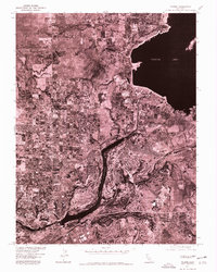
1975 Map of Folsom
USGS Topo · Published 1978About this map
Folsom Lake dominates the upper eastern quadrant of this 1975 orthophotoquad, revealing the shoreline and hydraulic infrastructure during the mid-1970s. This specialized map, produced in cooperation with the Soil Conservation Service, uses aerial photography to provide a literal visual record of land use and development patterns. The growing residential grid of Orangevale is clearly visible to the west, while the historical core and expanding suburban outskirts of Folsom sit between the two major water bodies. Below the dam, Lake Natoma carves a narrow path through the center of the sheet, framed by the distinctive patterns of local terrain and engineering. The imagery highlights the transition from natural riverbanks to managed reservoirs, capturing the footprint of industrial and residential growth in Sacramento County during this era.
Find a feature on this map
4 named features on this map. Tap any name to fly to it.
Don’t see what you’re looking for? This feature index may not catch every label — zoom into the map to look around manually.
Map Details
Editions of this 1975 Folsom Map
This is the sole edition of this map. No revisions or reprints were ever made.
Other maps of this area

1891 · Sacramento
USGS Topo · 1:125,000

1892 · Sacramento
USGS Topo · 1:125,000

1893 · Sacramento
USGS Topo · 1:125,000

1902 · Fairoaks
USGS Topo · 1:62,500

1908 · Buffalo Creek
USGS Topo · 1:31,680

1910 · Roseville
USGS Topo · 1:31,680

1911 · Mills
USGS Topo · 1:31,680

1911 · Antelope
USGS Topo · 1:31,680

1914 · Folsom
USGS Topo · 1:31,680
1916 · Buffalo Creek
USGS Topo · 1:31,680