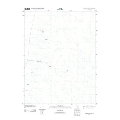
2011 Map of Fondaway Canyon
USGS Topo · Published 2011About this map
Fondaway Canyon and its many tributary drainages define this arid landscape in Churchill County. This 2011 survey illustrates the complex natural drainage patterns characteristic of the Nevada desert, where water features such as Shanghai Spring are critical markers for the region's geography. The map traces several distinct canyons including White Cloud Canyon, Shamrock Canyon, and Shady Run Canyon, each of which represents the significant geological erosion that has shaped this portion of the Stillwater Range. The detail of the canyon floors and adjacent heights like Pike Hollow provides essential context for those studying the physical history and natural topography of the Great Basin. While largely unpopulated, the naming of these specific canyons and basins indicates the deep history of mineral prospecting and local navigation in this corner of Nevada.
Find a feature on this map
9 named features on this map. Tap any name to fly to it.
Don’t see what you’re looking for? This feature index may not catch every label — zoom into the map to look around manually.
Map Details
Editions of this 2011 Fondaway Canyon Map
This is the sole edition of this map. No revisions or reprints were ever made.
Other maps of this area

1908 · Carson Sink
USGS Topo · 1:250,000

1910 · Carson Sink
USGS Topo · 1:250,000

1957 · Reno
USGS Topo · 1:250,000

1959 · Reno
USGS Topo · 1:250,000

1960 · Reno
USGS Topo · 1:250,000

1966 · Dixie Hot Springs
USGS Topo · 1:62,500

1969 · Cox Canyon
USGS Topo · 1:24,000
1969 · Lone Rock
USGS Topo · 1:24,000
1969 · Lone Rock SE
USGS Topo · 1:24,000
1972 · I X L Canyon
USGS Topo · 1:24,000