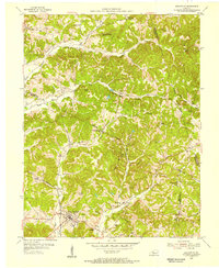
1953 Map of Fordsville
USGS Topo · Published 1955About this map
Fordsville serves as the primary hub of this Kentucky landscape, situated at the junction of the Illinois Central railroad lines. The mid-century economy of this region is clearly defined by numerous Oil Wells and an expansive Oil Field that stretches through the hilly terrain between Newton Springs and Easton. Significant family and community history is preserved through a dense network of country churches and burial grounds, including Boiling Chapel, Wesley Chapel, and the Wedding Cemetery. The topography is marked by distinctive elevations like Turkey Scratch Knob and Bald Knob, while rural life centers around small settlements such as Victoria Crossroads and Askin. Further north, the Sanders School and nearby Sanders Cemetery indicate a localized community structure that relied on the winding paths of the South Fork Panther Creek for geographic orientation.
Find a feature on this map
38 named features on this map. Tap any name to fly to it.
Don’t see what you’re looking for? This feature index may not catch every label — zoom into the map to look around manually.
Map Details
Editions of this 1953 Fordsville Map
2 editions found
Other maps of this area

1903 · Tell City
USGS Topo · 1:62,500

1907 · Whitesville
USGS Topo · 1:62,500

1909 · Whitesville
USGS Topo · 1:62,500

1932 · Fordsville
USGS Topo · 1:62,500

1934 · Cannelton
USGS Topo · 1:62,500

1953 · Dundee
USGS Topo · 1:24,000

1953 · Cloverport
USGS Topo · 1:24,000

1953 · Whitesville
USGS Topo · 1:24,000

1953 · Falls Of Rough
USGS Topo · 1:24,000
1953 · Mattingly
USGS Topo · 1:24,000