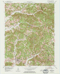
1953 Map of Fordsville
USGS Topo · Published 1973About this map
The Illinois Central railroad corridor serves as the primary artery through this dissected landscape, connecting the town of Fordsville with the rail stop at Ellmitch. In the mid-1950s, the region was defined by a mix of agricultural ridge tops and a burgeoning energy sector, with an active Oil Field and numerous Oil Wells scattered across the valleys of South Fork Panther Creek and Adams Fork. These industrial footprints share the terrain with a network of long-established rural community centers, often centered on small country churches like Oaks Ch and East Fork Ch.
Find a feature on this map
43 named features on this map. Tap any name to fly to it.
Don’t see what you’re looking for? This feature index may not catch every label — zoom into the map to look around manually.
Map Details
Editions of this 1953 Fordsville Map
2 editions found
Other maps of this area

1903 · Tell City
USGS Topo · 1:62,500

1907 · Whitesville
USGS Topo · 1:62,500

1909 · Whitesville
USGS Topo · 1:62,500

1932 · Fordsville
USGS Topo · 1:62,500

1934 · Cannelton
USGS Topo · 1:62,500

1953 · Dundee
USGS Topo · 1:24,000

1953 · Cloverport
USGS Topo · 1:24,000

1953 · Whitesville
USGS Topo · 1:24,000

1953 · Falls Of Rough
USGS Topo · 1:24,000
1953 · Mattingly
USGS Topo · 1:24,000