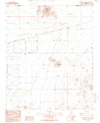
1990 Map of Forepaugh Peak
USGS Topo · Published 1990About this map
Aguila Valley dominates the central portion of this 1990 field-checked survey, revealing a landscape defined by water management and mineral extraction. The map details an extensive network of ditches and levees designed to direct water across the arid terrain, punctuated by numerous named water catchments such as Horse Pasture Tank, Joanette Tank, and Daniels Tank. These features suggest a period of active land use and livestock management in the basin between the northern highlands and the southern desert wash systems.
Find a feature on this map
28 named features on this map. Tap any name to fly to it.
Don’t see what you’re looking for? This feature index may not catch every label — zoom into the map to look around manually.
Map Details
Editions of this 1990 Forepaugh Peak Map
This is the sole edition of this map. No revisions or reprints were ever made.
Other maps of this area

1887 · Prescott
USGS Topo · 1:250,000

1892 · Prescott
USGS Topo · 1:250,000

1903 · Congress
USGS Topo · 1:125,000

1904 · Congress
USGS Topo · 1:125,000

1923 · Signal
USGS Topo · 1:250,000

1942 · Signal
USGS Topo · 1:250,000

1942 · Vicksburg
USGS Topo · 1:250,000

1950 · Prescott
USGS Topo · 1:250,000

1954 · Prescott
USGS Topo · 1:250,000

1954 · Phoenix
USGS Topo · 1:250,000