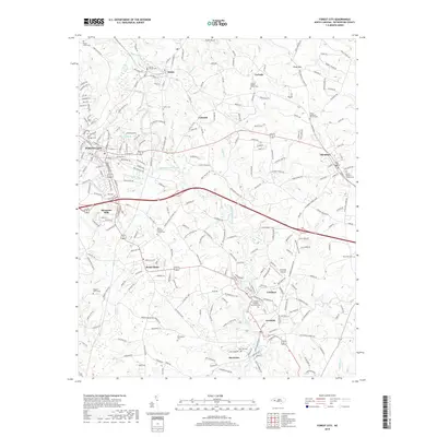
2019 Map of Forest City
USGS Topo · Published 2019About this map
The Second Broad River winds south through the heart of this Rutherford County landscape, anchoring a series of industrial and agricultural communities. This 2019 survey captures the developed corridor of Forest City and Alexander Mills, where the CSX rail line facilitates regional transport. The map reveals a dense concentration of historical sites essential for genealogical research, such as the Caroleen-Avondale Henrietta Cem and Doggett Grove Cem, alongside several rural congregations including Corinth Baptist Church. Toward the east, the terrain rises toward Piney Mtn and the town of Ellenboro, while the southern reaches feature the distinct settlements of Henrietta and Caroleen. This modern view documents the persistent layout of local roads like Walker Mill Rd and Race Path Church Rd, reflecting how the 21st-century infrastructure still follows the contours of the area's textile and rail heritage.
Find a feature on this map
258 named features on this map. Tap any name to fly to it.
Don’t see what you’re looking for? This feature index may not catch every label — zoom into the map to look around manually.
Map Details
Editions of this 2019 Forest City Map
This is the sole edition of this map. No revisions or reprints were ever made.
Other maps of this area

1909 · Gaffney
USGS Topo · 1:62,500

1950 · Shelby
USGS Topo · 1:62,500

1953 · Charlotte
USGS Topo · 1:250,000

1954 · Charlotte
USGS Topo · 1:250,000

1959 · Cowpens
USGS Topo · 1:62,500

1960 · Charlotte
USGS Topo · 1:250,000

1962 · Charlotte
USGS Topo · 1:250,000
1965 · Sunshine
USGS Topo · 1:24,000
1966 · Rutherfordton North
USGS Topo · 1:24,000

1966 · Forest City
USGS Topo · 1:24,000