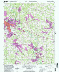
2002 Map of Forest City
USGS Topo · Published 2003About this map
The Second Broad River winds through this Piedmont landscape, anchoring a corridor of textile history and rural settlements. Industrial clusters like Alexander Mills, Caroleen, and Henrietta line the river banks, reflecting the region's manufacturing legacy. The map reveals a dense network of local landmarks, from the Drive-in Theater near Sandy Mush to the Copper Mine and various Sandpits that speak to the area's geological utility. Educational and civic life is centered around institutions such as East Rutherford High Sch and the Avondale-Henrietta Sch. Numerous family and community burial sites, including Smith Grove Ch Cem and Trout Cem, are scattered across the terrain, providing essential touchpoints for genealogical research. The presence of several dismantled railroad lines indicates a changing transportation infrastructure as the 21st century began.
Find a feature on this map
75 named features on this map. Tap any name to fly to it.
Don’t see what you’re looking for? This feature index may not catch every label — zoom into the map to look around manually.
Map Details
Editions of this 2002 Forest City Map
This is the sole edition of this map. No revisions or reprints were ever made.
Other maps of this area

1909 · Gaffney
USGS Topo · 1:62,500

1950 · Shelby
USGS Topo · 1:62,500

1953 · Charlotte
USGS Topo · 1:250,000

1954 · Charlotte
USGS Topo · 1:250,000

1959 · Cowpens
USGS Topo · 1:62,500

1960 · Charlotte
USGS Topo · 1:250,000

1962 · Charlotte
USGS Topo · 1:250,000
1965 · Sunshine
USGS Topo · 1:24,000
1966 · Rutherfordton North
USGS Topo · 1:24,000

1966 · Forest City
USGS Topo · 1:24,000