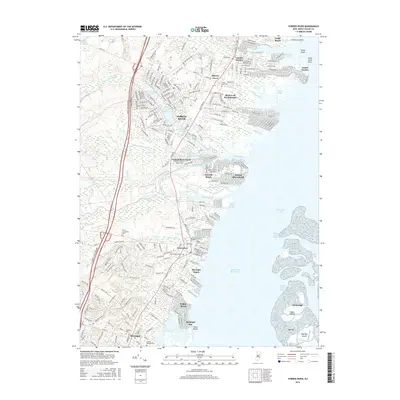
2016 Map of Forked River
USGS Topo · Published 2016About this map
Forked River and Waretown anchor this coastal landscape, illustrating the intricate relationship between New Jersey's mainland and the Barnegat Bay. The area is defined by its extensive water network, where the N Br Forked River, Middle Branch Forked River, and South Branch Forked River converge to meet the bay. This modern survey shows a high density of established residential development in waterfront communities like Lanoka Harbor and Riviera on the Barnegat, characterized by numerous man-made lagoons and finger piers that extend into the estuaries. For local historians and genealogists, the map preserves the locations of several important burial sites, including the Old Waretown Cem and Good Luck Cem. The presence of the NJ State Game Farm and the Garden State Parkway highlights the dual nature of the region as both a preserved natural area and a primary transit corridor for the Jersey Shore.
Find a feature on this map
58 named features on this map. Tap any name to fly to it.
Don’t see what you’re looking for? This feature index may not catch every label — zoom into the map to look around manually.
Map Details
Editions of this 2016 Forked River Map
This is the sole edition of this map. No revisions or reprints were ever made.
Other maps of this area

1884 · Whitings
USGS Topo · 1:62,500

1888 · Barnegat
USGS Topo · 1:62,500

1888 · Little Egg Harbor
USGS Topo · 1:62,500

1888 · Long Beach
USGS Topo · 1:62,500

1888 · Whitings
USGS Topo · 1:62,500

1893 · Little Egg Harbor
USGS Topo · 1:62,500

1893 · Long Beach
USGS Topo · 1:62,500

1893 · Barnegat
USGS Topo · 1:62,500

1898 · Barnegat
USGS Topo · 1:62,500

1919 · Long Beach
USGS Topo · 1:62,500