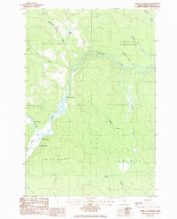
1986 Map of Forks of Machias
USGS Topo · Published 1986About this map
Machias River dominates this portion of the North Maine Woods, where the waterway meanders through a landscape defined by timber harvesting and isolated outposts. In the mid-1980s, the area remained largely undeveloped, characterized by the remote Garfield Plantation and various township boundaries like T 11 R 7 W E L S. The confluence at the Forks of Machias serves as a central landmark, situated near the V E Lynch Camp, representing the deep-woods tradition of sporting camps and logging operations in Aroostook County. Numerous tributaries, including Punchard Brook and McConnell Brook, feed the main river, while Grassy Landing provides a specific point of access along the water's winding path. This geography reflects a specialized wilderness economy where private roads and small water bodies like Pingree Pond were the primary markers of human presence.
Find a feature on this map
19 named features on this map. Tap any name to fly to it.
Don’t see what you’re looking for? This feature index may not catch every label — zoom into the map to look around manually.
Map Details
Editions of this 1986 Forks of Machias Map
This is the sole edition of this map. No revisions or reprints were ever made.
Other maps of this area

1930 · Greenlaw
USGS Topo · 1:48,000

1931 · Ashland
USGS Topo · 1:48,000

1933 · Greenlaw
USGS Topo · 1:62,500

1934 · Ashland
USGS Topo · 1:62,500

1940 · Oxbow
USGS Topo · 1:62,500

1942 · Oxbow
USGS Topo · 1:62,500

1953 · Ashland
USGS Topo · 1:62,500

1954 · Grand Lake Seboeis
USGS Topo · 1:62,500

1954 · Presque Isle
USGS Topo · 1:250,000

1958 · Presque Isle
USGS Topo · 1:250,000