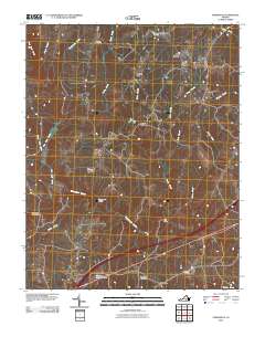
2010 Map of Forksville
USGS Topo · Published 2010About this map
The Meherrin River flows across the southern portion of this landscape, its path marked by infrastructure such as the Union Mill Bridge and Dix Bridge. The terrain north of the river is defined by an intricate network of waterways, including Stony Creek, Broad Branch, and Bold Branch, which carved the drainages that shaped early settlement patterns. Small communities and historical junctions like Lochleven, Gills Corner, and Bacons Fork are scattered throughout the region, reflecting a rural Virginia economy centered on crossroad hamlets and milling sites.
Find a feature on this map
31 named features on this map. Tap any name to fly to it.
Don’t see what you’re looking for? This feature index may not catch every label — zoom into the map to look around manually.
Map Details
Editions of this 2010 Forksville Map
This is the sole edition of this map. No revisions or reprints were ever made.
Other maps of this area

1918 · Lawrenceville
USGS Topo · 1:62,500

1919 · White Plains
USGS Topo · 1:48,000

1920 · Lawrenceville
USGS Topo · 1:48,000

1920 · White Plains
USGS Topo · 1:62,500

1921 · Lawrenceville
USGS Topo · 1:62,500

1942 · Lawrenceville
USGS Topo · 1:62,500
1951 · Danieltown
USGS Topo · 1:24,000

1953 · Norfolk
USGS Topo · 1:250,000

1953 · Greensboro
USGS Topo · 1:250,000

1954 · Greensboro
USGS Topo · 1:250,000