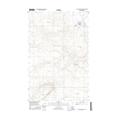
2017 Map of Fort Belknap Agency
USGS Topo · Published 2017About this map
Fort Belknap Agency and the nearby residential area of Newtown serve as the focal points of this northern Montana landscape, situated just south of the winding Milk River. This 2017 study illustrates the modern geography of the Fort Belknap Indian Reservation, where the BNSF Railway tracks parallel the river corridor to support regional commerce. To the south, the terrain rises toward Snake Butte, a prominent geological landmark. The map detail highlights an essential local infrastructure, including the Fort Belknap Agency Airport and the Agency Cem. Wide expanses dedicated to the Bison Grazing Field reflect the intersection of traditional land use and contemporary conservation efforts, while a network of rural routes like Snake Butte Rd and Timber Ridge RD connect the prairie uplands to the settlement center.
Find a feature on this map
23 named features on this map. Tap any name to fly to it.
Don’t see what you’re looking for? This feature index may not catch every label — zoom into the map to look around manually.
Map Details
Editions of this 2017 Fort Belknap Agency Map
This is the sole edition of this map. No revisions or reprints were ever made.
Other maps of this area

1903 · Wayne Creek
USGS Topo · 1:62,500

1905 · Wayne Creek
USGS Topo · 1:62,500

1905 · Harlem
USGS Topo · 1:62,500

1913 · Cherry Ridge
USGS Topo · 1:125,000

1953 · Havre
USGS Topo · 1:250,000

1957 · Havre
USGS Topo · 1:250,000

1958 · Havre
USGS Topo · 1:250,000

1964 · Threemile Reservoir
USGS Topo · 1:24,000
1964 · Fort Belknap Agency
USGS Topo · 1:24,000
1964 · Big Coulee
USGS Topo · 1:24,000