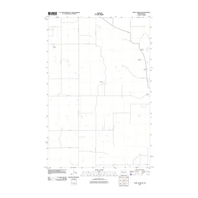
2011 Map of Fort Clark NE
USGS Topo · Published 2011About this map
Sanger Cemetery and Bagnell Cemetery occupy the high ground above the Missouri River valley in this 2011 survey of eastern Oliver County. This sparsely populated agricultural landscape is defined by the legacy of early ranching and riverfront settlement, marked by established properties like the Van Oosting Ranch and the OK Ranch. The terrain shows a transition from the rolling uplands down toward the Missouri floodplain, where the Cross Ranch state park provides a buffer of protected prairie and woodland along the water. Genealogists can find several family-named landmarks here, including Gaines Cemetery, which sits north of the junction of 15th St SW and 25th Ave SW. The map documents a grid of section-line roads, such as 12th St SW and 29th Ave SW, that maintain the rural character of this North Dakota river country.
Find a feature on this map
18 named features on this map. Tap any name to fly to it.
Don’t see what you’re looking for? This feature index may not catch every label — zoom into the map to look around manually.
Map Details
Editions of this 2011 Fort Clark NE Map
This is the sole edition of this map. No revisions or reprints were ever made.
Other maps of this area

1949 · Turtle Creek
USGS Topo · 1:62,500

1949 · Washburn
USGS Topo · 1:62,500

1950 · Wilton
USGS Topo · 1:62,500

1954 · McClusky
USGS Topo · 1:250,000

1958 · McClusky
USGS Topo · 1:250,000

1961 · Turtle Creek SW
USGS Topo · 1:24,000

1961 · Washburn
USGS Topo · 1:24,000

1966 · Price
USGS Topo · 1:24,000
1966 · Sanger
USGS Topo · 1:24,000

1967 · Washburn SW
USGS Topo · 1:24,000