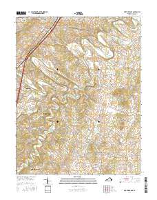
2016 Map of Fort Defiance
USGS Topo · Published 2016About this map
The Middle River meanders across this Shenandoah Valley landscape, defining the northern geography of the area surrounding Fort Defiance and Mount Sidney. To the south, the terrain is characterized by a series of significant drainage paths including Christians Creek, Meadow Run, and Coleytown Run. The mapping reveals a densely settled agricultural and residential corridor along the Western flank near Verona and Fishersville, while the central and eastern sections maintain a pattern of rural crossroads and distinct landforms such as Kennedy Ridge and Round Hill. Genealogists will find several notable burial grounds, including Belmont Cem, Saint Paul Cem, and Hildebrand Cem, scattered across the undulating valley floor. The placement of small communities like New Hope, Hermitage, and Knightly shows the enduring importance of local milling and farming hubs, connected by a network of historic routes like Knightly Mill Rd and Battlefield Rd.
Find a feature on this map
98 named features on this map. Tap any name to fly to it.
Don’t see what you’re looking for? This feature index may not catch every label — zoom into the map to look around manually.
Map Details
Editions of this 2016 Fort Defiance Map
This is the sole edition of this map. No revisions or reprints were ever made.
Other maps of this area

1892 · Harrisonburg
USGS Topo · 1:125,000

1894 · Staunton
USGS Topo · 1:125,000

1934 · Waynesboro
USGS Topo · 1:48,000

1939 · Waynesboro
USGS Topo · 1:62,500

1941 · Harrisonburg
USGS Topo · 1:62,500

1943 · Harrisonburg
USGS Topo · 1:62,500

1944 · Parnassus
USGS Topo · 1:62,500

1944 · Staunton
USGS Topo · 1:62,500

1947 · Staunton
USGS Topo · 1:62,500

1947 · Parnassus
USGS Topo · 1:62,500